PLEASE NOTE:
The fields around Cronk Howe Mooar sometimes contain livestook.
Please proceed with care if this is the case. It would be advisable not to take dogs on the walk.
Nowadays, Cronk Howe Mooar is just a large green hill rising up from a flat landscape, and you need a strong imagination to see it for what it really is - the remains of a 900-year-old fort.
This is a site which, when it was dug over 100 years ago, was completely misinterpreted by the archaeologists. Virtually nothing they said about this hill turned out to be true. And that’s not to criticise them, it’s just that they interpreted what they found in the light of knowledge available in 1912. Since then we’ve learnt a great deal more about this type of structure and can now give a much more accurate account of what it’s all about.
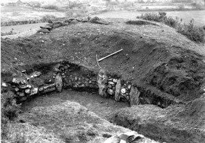
When Philip Kermode dug here a century ago, he cut a section into the side of the hill and as he went in he found distinct layers, first of sand, then clay, then loose gravel and then more clay.

These were only relatively shallow layers but it made him come to the conclusion that this was an entirely natural hill, formed at the end of the last Ice Age by material being washed down from the melting glaciers.
But we now know that this didn’t happen here – if it had done, how come all the land around this area has been removed leaving just this mound? No – geomorphologists, those people who study the processes that shape the land, are quite clear that this hill is not a natural feature: it’s manmade, and that makes it incredible.
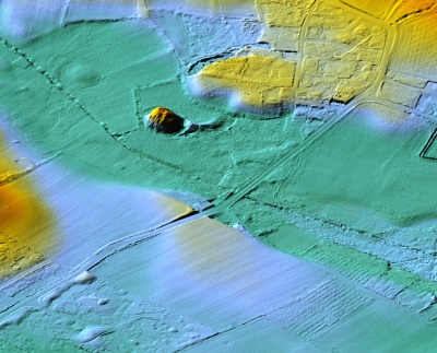
What we can see from nearby is a definite trench, a moat, running round the base of the hill, and another manmade section, a great ramp that comes up to the edge of the moat.

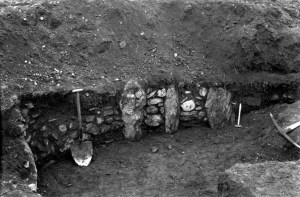
When the archaeologists dug a section on the top of the mound last century, they found the remains of a great pit, that was lined with stones. If you look at one of the photographs from the dig, you can see how it looked. Their conclusion was that people had adapted this so-called natural mound to use as a defensive area, and that they fought from behind a rampart running round the top of the hill.
Unfortunately, that was wrong as well. What we now know is that this is a classic motte and bailey castle. It has all the elements of a type of defensive structure introduced by the Normans when they invaded England in 1066.
It has an artificial hill with a moat around it. A ramp coming to the edge of the moat where there would have been a drawbridge, and an area beyond, on the flat ground, where a paling fence would have protected people and buildings, and maybe livestock as well.
The pit on the top was actually the base for the castle that once stood there, probably made of wood.
So why was the mound made in layers? Well, this was a technique developed by the Normans to give greater stability to these artificial hills. If it was just a great pile of soil, then it’s likely it would erode or eventually wash away. The layering strengthened the structure, and if Kermode had dug further through the hill he would probably have found the remains of large timbers as they were often included for added stability.

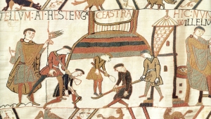
We actually have a picture of the Normans constructing the first ever motte and bailey they built in England, before they won the Battle of Hastings, and it’s in that remarkable piece of stitching, the Bayeux Tapestry.

It is a record of the preparation for, and the actual battle of, Hastings. The detail is extraordinary, and at one point, a group of Normans are busy building a castle, with simple shovels. But they’re building it in layers.
The different coloured stitching indicates layers of different types of earth. A remarkable construction, and just what we’ve got at Cronk Howe Mooar.
Constructing this must have been hard work. A motte of similar size in Berkshire has been analysed and it’s claimed it contains 22,000 tons of soil, and it took fifty men eighty days to build, and of course all the different materials – the clay, gravel, sand and so on would have to be found and brought here to create the layers, so it’s a massive commitment of time, energy and money.
We can only speculate who might have built this castle and why. Around the beginning of the 12th century the whole of the Irish Sea area was in turmoil with kings and earls trying to consolidate their various positions, and a Welsh Chronicle of the time tells us that in 1102 King Magnus Barelegs came to the Island and built himself three castles, ordering the men of Galloway in Scotland to bring timber here for that purpose. Maybe this is one of the castles that he had built.
If you'd like to read the article by P M C Kermode on Cronk Howe Mooar published in 1914, click below:
The Fort on the Cronk-Howe-Mooar
Cronk Howe Mooar from Culture Vannin on Vimeo.
View this video to learn more about Cronk Howe Mooar.
View a map of other places on the Island